Tourist sites in Gaza
Great Omari Mosque
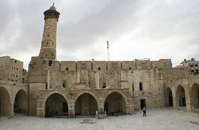
Located in downtown Gaza at the end of Omar Mukhtar Street, al-Umari mosque with its beautiful minaret used to be a Norman church built by the Crusaders in the 12th century. It is said to occupy the site of the first ancienttempleofMarnas.
Napoleon’s Fort – Qasr AL-Basha
Located on Al-Wahda Street in downtown Gaza, this imposing stone building dates back to the Mamluk period. It is known as Qasr al-Basha because Napoleon spent a few nights here on his way through the town in 1799.
Anthedon Harbour

The archaeological site of the ancient harbor city of Anthedonis located along theMediterranean Sea, in the northern corner of the Gaza Strip. Anthedon is the first known seaport ofGaza. It was inhabited from 800 BC to 1100 AD.
Anthedon represents a clear example among seaports along the Eastern Mediterranean coast, demarcating the ancient trade route that linked Europe with theLevantduring the Phoenician, Roman, and Hellenistic periods. Abundant archaeological evidence provides a complete and comprehensive picture of the historical and archaeological evolution in the region, which reflects the rich socio-cultural and socio-economic interchange between Europe and theLevant.
Tell Umm Amer
%E2%80%AC.JPG)
The site of Tell Umm Amer is located in Al Nusairat village on the Mediterranean Coast, 8.5 km south of Gaza City. The first settlement in the site was established during the Roman era. It appears on the Madaba map with the name Tabatha. The Site contains the ruins of Saint Hilarion (born 291 AD), which consist of two churches a burial site and a baptism hall, a public cemetery, an audience hall, and dining rooms.
The site is tangibly associated with the phenomenon of the flowering of Monastic desert centers inPalestineduring the Byzantine period. St. Hilarion’s monastery was perhaps a center of missionary work inGazaregion, seemingly isolated in the desert but actually at the center of affairs at communications cross-roads between Egypt, Palestine, Syria and Mesopotamia.
Arts & CraftsVillage

The centre contains an art gallery and handicraft workshops which offer high quality articles for sale. Don’t miss the highly agreeable Café Abu Nawwas in the complex.
Address: JamalAbdel Nasser Street, nearal-AzharUniversity. Tel: 08-284 6405.
Open daily except Friday.
The Pottery Workshop

Situated near the el-Faras market, the pottery workshop is unique. Pottery-making in Gazah as inherited a long tradition. From the Greek to the Byzantine period, amphorae called ” Gaza jars” filled with olive oil, wine or brine could be found all over the eastern Mediterranean. Today, the jars are principally decorative in purpose. They are usually of generous proportions, but one may also find smaller versions: in particular, water coolers whose unglazed clay is perfect for keeping water fresh and cool. The techniques of fabrication, firing and storing these pieces of pottery give their workshop a character of its own.
Khan Younis

Khan Younis, located in southwest Palestine, is the second largest city of the Gaza Strip next toGazaCity. It is 25 kilometers south ofGaza, 20 kilometers north of the Egyptian borders, and 4 kilometers from theMediterranean Sea.
The city’s name is formed of two words—Khan meaning hostel and Younis, which refers to Prince Younis Dawadar who built a garrison in 1387 for soldiers guarding travelers and pilgrims on their way to Jerusalem and Mecca. The town square is bordered by this impressive historic fortress that dominates the view.
In the old times, the city functioned as a station for commercial caravans. It gained special significance for its strategic location connecting theNileValleyto the Fertile Crescent,Egypt, and theArabian Peninsula.
Khan Younis is a market town for agricultural produce from the surrounding villages. It is worth a visit on Wednesdays and Thursdays during the weekly, colorful Bedouin Market, where merchants sell everything from embroidery to fish. There also are several cafés around the town center where you can sit down to eat local food or sip Arabic coffee.
Rafah

The ancient city of Rafah is and has been for many years the southern port to Palestine, a port that was the cause of many battles fought against invaders ofPalestinein the north and Egypt in the south.
One of Palestine’s oldest cities, Rafah formed a natural border between Egypt and the Fertile Crescent. Marble colonnades and obelisks were erected to mark the boundary between Palestine and Egypt.
The name of the city, currently home to 130.000 residents, appeared alongside the name Gaza in pharaohs’ scripts dating back to the 16th century B.C.E. The city was used as a primary guard point along the Hawras coastal road, which witnessed increased activity when the pharaohs came into full power.
Rafah was known in the Islamic era as a rest station for travelling merchants. Historians in the 11th century described the city as an industrious hub, featuring a market, a mosque, and several hotels and shops. Archaeologists believe that the sands of the western part of Rafah cover ruins belonging to the Roman era.
Wadi Gaza Coastal Wetlands

Wadi Gaza springs from the Negev hills and the southern heights ofHebron. The length of the Wadi is about 105 km from its source, and extends from the Truce line in East Gaza to the coast where it discharges into the sea.
The Wadi is distinct for its twists and turns, notably it makes eight curves when it crosses the Gaza Strip.
The Wadi Gaza is considered as one of the most important coastal wetlands located on theEasternMediterraneanBasin, very rich in Biological diversity (both Flora and Fauna). The wadi is also a station point for the migratory routes from north to south and from south to north.
Subscribe to:
Post Comments (Atom)


.JPG)
0 التعليقات: